
OLD SERBIA

OLD SERBIA
“Old Serbia”, as a notion and term, appears frequently not only in science and politics but also in everyday life. Its’ origins come from life’s practice, and the necessity for Serbs to identify with an ethnic entity and cultural-historical existence within a defined geographical area. Not infrequently, the borders were defined by unstable political state of events and other social-historical processes that had been going on for centuries.
It has not been ascertained when the name of Old Serbia occurred for the first time, at least not in written sources. It existed as a name amongst the people, perhaps opportunistically, before making any appearance in writing. It is supposed to have been propagated through oral communication during the period of the Great Migration of Serbs in 1690. These refugees and migrants were flocking to the territories of historical Hungary, for example in Slavonia, Baranja and Banat. Areas that the Serbs inhabited in the 18th century are called the “Racka” land (“Ratzenland”, Rácsország) – the land of Rasans – Serbs. This required distinguishing the real, old fatherland from where the migration under Patriarchs Arsenije III and Arsenije IV Shakabenta commenced. The works of Jakov Ignjatović established that in some places this notion of old fatherland in Serbia– a century and a half after the Great Migration –actually apostrophized by becoming the new homeland in Hungary under the general name of Old Serbia.
However the real historical meaning of the notion and term “Old Serbia” occurred only in the beginning of the 19th century after the creation of the new Serbian state under Karadjordje and Duke Miloš, of Serbia, the Principality of Serbia. Establishing the Principality was in contrast to the not-yet liberated part of former (medieval) Old Serbia, which remained under Turkish rule until 1877-1878. (The exception was the northernmost part, which was finally liberated in 1912.)
The issue of Old Serbia (or about Old Serbia) can be considered in a two- or threefold dimension: having historical/symbolic meaning, in a geopolitical area and in an ethnographic aspect. Even as territories that is, the preservation of unique cultural heritage by maintaining monuments, buildings, art and painting. It is understood that certain differences in comprehending the scope and territorial area of Old Serbia existed. Regarding these, three viewpoints can be presented.
Most generally, it is – first of all – expressed throughout Vuk’s studies that Old Serbia was the territory of “our people” that belonged to the Serbian state before the Balkan peninsula was conquered by the Turks. According to the work of other authors this corresponds to the state created under Czar Dušan. Under Old Serbia, still others wrote, one should understand the territory of the Serbian Kingdom under Milutin and Stefan Dečanski—before Dušan’s imperial conquer.
In the narrowest sense, Old Serbia was considered as an ethnic nucleus, and center of medieval state in the Nemanjić period. The state covered Old Rascia (Stara Raška), Kosovo, Metohija, the river basin of Binacka Morava, and the north Vardar area with Skopje. During the 19th century, Turkish territory shared borders to the north and west with the free states of Serbia and Montenegro, and on the south and southeast, with borders of the Serbian Archbishopry of Peć (before 1346). They contained the boundaries of Turkish Skopje “sanjak”, (afterwards Kosovo’s “vilayet”, seated in Prishtina—that is, in Skopje).
Nevertheless, there were authors who took, for the borders of Old Serbia, the entire area of the Turkish Rumelia Vilayet—from Drim on the west to Struma on the east, and on the south to the ethnographic boundaries of the Serbian-Slav world with Greco-Tzintzar ethnic settlements. This was generally the direction: Berat-Kostur-Serbia (Serfidge)-Salonica. The Turkish invasion on the Balkans was taken as the historical landmark for the up-to-then territorial-political and state-legal restriction between the Balkan states and peoples, but also the major cause for all later alterations and consequences.
In order to explain these facts better it is necessary, first of all, to determine what was usually considered as Serbia in the later time of the Turkish rule, when the Turkish administration on the Balkan Peninsula was stabilized, and its relations with the subjugated Balkan peoples were completely regulated. It should be mentioned that the Turks introduced their names for the conquered lands according to the names of the provinces (“beglerbergluk”) and regions (“sanjakats”).
One of the first who competently stated his understanding of the territory and the borders of Serbia was Marin Bicci, archbishop of Bar and “primas” of Serbia. In his reports from 1618 (“Relatio Status Ecclaesiae Antebarensis”) to the Roman Curia (“Sanctae Sedis Apostolicae”), Bicci included the entire Prizren archdiocese territorially in the borders of the Serbian Kingdom (“in limitibus Regni Serviae”). Besides Skopje (“in Serviam preter Scopiam”) and Prizren, the catholic “župas” of Janjevo and Novo Brdo, then Prokuplje and Novi Pazar belonged to Serbia. In all these places, except for Janjevo, the Turks Muslims (“infidelii”) made the majority of population, after whom, in significantly lesser number, were the Orthodox Serbs (“Schismatici”), and then the Catholics (“Latini”). It is interesting that then, out of 500 households (“quiengentus domus”), the Orthodox Serbs were the most numerous in Janjevo – with 190 houses; the Latins had 120 homes, and the others were “unbelievers” – Muslims.
However, according to the report of the new archbishop of Bar Peter Masarek, the catholic “župas” in Trepča, in Letnica (Skopje Montenegro) and in Kratovo belonged to Serbia (in Regno di Servia) of that time. In Serbia, in the area of Boka Kotorska to the Danube and the Morava watershed towards the Archbishopric in Sofia, and to Kratovo and Skopje on the south, i.e. on the territory of the “primas” of Serbia, there were twenty one parishes with 5,000 Catholics in 1640 (“La Parochie comprese quelle di Servia sono numero 21…”). Skopje was considered the old capital of Serbia, in which 20,000 Turkish, 200 Orthodox and 120 Jewish families (“case”) lived, and only 40 Catholic souls (“anime”).
As can be seen from this, the church territorial jurisdiction of the Catholic Prizren (Skopje) Archbishopric, in this part of the Balkan Peninsula, was considered to be located on the territory of Serbia (“Regnum Serviae”), of which the south centers were: Prizren, Skopje, Kratovo, certainly with their civil administrative (Turkish) regions. Whether the important economic center of Tetovo (Kalkandelen), with the area (of both) Pologs belonged in the canonical jurisdiction of the Prizren (Skopje) Archbishopric, i.e. the “primas” of Serbia, can not be seen from the document of the Catholic Province, because, probably, there were no Catholics recorded in it. It is known, however, that the Tetovo Kadiluk belonged administratively to Prizren, i.e., Skoplje “sanjak” which – as mentioned before – belonged to Regnum Serviae. The south borders of the renewed Patriarchy of Peć (1557) actually coincided with the landmarks of the Prizren and Skopje “sanjak” in the south direction of the Rumelia “belgerberluk”. (The Tetovo “kadiluk” comprised the Gostivar “nahiya” in the south as well).
The western, i.e., southwestern borders of the Skopje Archbishopric – towards the Drachia Archbishopric were on the river Drim which divided Serbia from Albania (“Drino…sempre suo divisovo”), with Skopje as the old capital of the “former kings of Serbia”. On the basis of this report of the Skopje Archbishop from 1685 and after Bicci, more than six decades after, it is understood that under Serbia the ancient territory of Dardania and coastal Macedonia – the whole area between Albania and Bulgaria was meant. It is not clear whether the eastern, or rather the southeastern border of Serbia from the time of its kings, in this report meant the (geographical) border of Macedonia in this direction of its “meridional” expansion. In any case, it was emphasized that Skopje was the capital of Serbia (“Scopia detta da Greci anche Heraclia Metropoli di Servia”). For this Skopje it is said that in 1685 (prior to the coming of the imperial-Austrian army in 1689) it had 200 “case greche, e Serviene”. According to the same report in Prizren and Skopje “rissiedevano li Despoti di Servie” and in Pec there was the Patriarchy residence (“in Servia, il luago di Pech, ressidenza del Patriarca Serviano in un Monasterio suontussisimo”).
The spatial area of the Skopje Archbishopric on the north bordered with the territory of the Smederevo-Belgrade Catholic (Arch)bishopric, which comprised northern parts of Serbia, and spread, actually to the middle geographic part of the medieval Serbian state, where the most important economic sources were found: mines, markets, fertile (“župa”) ravines and pastures, then the major communication knots, two imperial capital cities, the seats of the Archbishopric and the Patriarchy, the most important monasteries (“imperial lauras”) and churches and the famous Kosovo “polje” (Field of Blackbirds).
In the acts of Pope’s office it was taken that Serbia in the jurisdiction of the Skopje (Prizren) Archbishopric was divided into two parts: upper and lower Serbia. The Pope’s reports are very interesting and from the aspect of ethnical, confessional, population and demographic conditions.
In that way, in the census made by Giorgio Bianci, the Bar Archbishop in 1638, in the area of “di Servia superiore”, were towns with a Catholic population: Prokuplje, Trepča, Novo Brdo, Prishtina, Janjevo, Skopje, Kratovo and the region of Montenegro (Skopje: Monte Negro). This Catholic population spoke the Serbian language (“Tutti questi sono in Servia Superiore, e parlano in lingua Illirica”). Besides these towns in “upper” Serbia, there were Catholics in the following town of “lower” Serbia (“Servia Inferiore”): Prizren, Djakovica (Pec). In both parts of Serbia of the Skopje Archbishopric (“In Servia Superiore e Inferiore”) lived a total of 4,260 Catholics.
At the same time, for Djakovica, according to the testimony of the missioner fra Bonaventura da Palacuola, in 1637, from about 500 homes, only 20 were Catholic in this town, and “il resto tutti Turche, et Scismatici”. It was characteristic for the Djakovica surrounding that there were “di Turchi assai, assai” in the nearby villages around Djakovica, while at the north of Djakovica towards Dečani, “schismatics” prevailed (“Per andar dalla parte del Settentrione sopra Jacova incominciano li Scismatici”). So, there were a lot of Muslims, while the Orthodox dominated especially north of Djakovica, and there was a small number of Catholics. They all spoke (the Catholics and Orthodox) the Serbian language (which applied to the Muslims at large).
This demographic-statistical image of Djakovica’s surroundings especially of the Serbian-Orthodox majority was also testified by fra Cerubin in March, 1638 who cited that “una giornata di là Jacova, dove sono quasi tutti Scismatici, e imparticolar, dove è um belissimo Monasterio” – Dečani. Right on the way from Dečani to Djakovica this friar found “molte ville di Scismatici”. Moreover Archbishop Bianci, wrote to the Congregation in October 1641 that the year before, in 1640, the plague raged through Serbia in the towns of Skopje, Janjevo and Novo Brdo – which were in la Servia superiore, while Prizren “che e Servia inferiore” was spared from this epidemic.
The same Archbishop, counted the Catholics in the towns “nel Regno di Servia inferiore, et superiore”: Prizren, Djakovica, Prokuplje, Skopje, Novo Brdo, Janjevo, Kratovo in 1642. At the end of 1645, Francesco de Monoris reported to the Congregation that the mountains west from Dečani divide the basin of Beli Drim (White Drim) from Albania (“dividono la Servia dall Albania”), and that Skopje was found belonging to the Peć Archibishopric, i.e. the Skopje (Orthodox) Bishopric. Therefore, Drim was the border between Serbia and Albania, and this border was mentioned later in the Pope’s sources.
The religious-church conditions on the terrain of the Skopje (Prizren) Catholic Archbishopric, i.e. in its jurisdiction over very rare Catholic population of Arbanas and Slavs (Serbs), was studied by Serbian historians Jovan Radonic and Jovan Tomić, who besides that went into the problems of confessional, ethnical and demographic of this part of Old Serbia. These processes and oscillations in the mentioned interrelations were in close connection with the political conditions in the Ottoman Empire, but also in the larger dependency of peace and war conditions between Turkey and the neighboring Christian states: Venetia, Austria and Russia. In any case the Papal (Roman) sources quite accurately portrayed the general situation, as well as the particular characteristics in these parts of Old Serbia, primarily in Metohija, and – partly – in neighboring Albania, on the territory of Arbanas Malesors, consisting mainly of Catholics.
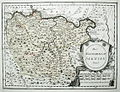
In the scientific field, cartography represented an important means of spreading information that was both a public announcement of general knowledge and of interest to political and social thought. In the 17th and 18th centuries its role was important because it visually showed concrete situations, for instance, in political relationships, relief, communications and such, which was of great significance both for science as well as for politics, economy and trade. The big Austro-Turkish war, which started with the siege of Vienna in 1683, since it moved in 1688-1690 to the Balkan Peninsula as well, did not much expand knowledge in cartography, but it did introduce some important geopolitical objects that were either unknown or erroneously known earlier. As for Serbian historians, the geographical knowledge about Serbia at that time was entirely known by Nikola Radojčić, and a survey of cartographic editions about Serbian lands was critically reviewed by Jovan Cvijić.
Regarding the matter of Old Serbia, in a direct or indirect way, it was of little importance to acquire the correct insight about the real conditions of the territory, first of all because the existing, current folk names for certain areas and regions were – because of disinterest – expressed by ancient names, i.e., traditional nomenclature. Austrian cartography did much there – covering areas as far as northern Serbia, Bosnia, and the Danube area generally. In this respect, the military-geographic descriptions of Austrian intelligence officers were very important and in many cases almost completely accurate, but their interests do not relate a lot to the regions of Old Serbia and neighboring Albania, Macedonia or Bulgaria. A part of these expert forays into Serbian local science was published by Dušan Pantelić.
However of all the geographic descriptions of Serbia dating from the beginning of the 19th century, the most important was Weingerton’s (1820), whose area of consideration applies to parts of Old Serbia too, i.e., that part of it which remained under Turkish rule after the Second Uprising in 1815 in the Belgrade “pashaluk”. A critical review of this document was written by Vuk Karadžić, and ten years later it appeared as the first realistic survey: “Geografičesko-Statističesko opisanije” (Geographic-Statistical description) of Serbia (1826-1828).
The ethnical borders of one people do not necessarily have to coincide with the political borders of its national state, nor do they have to include a complete geographic area. The First Serbian Uprising liberated only a part of the peoples in Serbia, in the Ottoman Empire and in Turkey, although their aim was common – liberation from the Turks and the creation of their peoples’, national state. Lazar Arsenijević Batalaka, a contemporary and participant in the events of the First Serbian Uprising wrote about it: “We do not have any written trace of our homogenous in Bosnia, Herzegovina, Old Serbian and Montenegro… The only thing we have and which continues and lasts, are only our mutual wishes, because the Bosnians, the Herzegovinians, and the inhabitants of Old Serbia, the Serbs, want to get rid of the Turkish shackles…” Batalaka claims that Karadjordje’s “intentions were …for…Bosnia, Herzegovina and Old Serbia (to rise up)”. Rodofinikin, the Russian representative in Serbia in his “Notes” (“Zapiske”) (1808), wrote that the renewal of the Serbian state ought to, besides the already liberated parts of northern Serbia, to include old towns of medieval Serbia – Novi Pazar, Skopje and Niš (certainly with their administrative regions), in other words, a part of Old (historical) Serbia.
That it was known, and outside of Serbia, that these (mentioned) parts belonged to Old Serbia, is testified by a French official report of colonel Merigiaz from April 20, 1808 from Vidin, according to which: “Les Serviens occupent maintenant presque toute l’ancienne Servie à l’exception de Nissa, de Lescovitza et de quelque petites places au pied des montagnes qui les séparent de la Macédoine et de l’Albanie” (This broader area de l’ancienne Servie between Bosnia, Albania and Macedonia was also mentioned in another French report of General Sebastian, from July 12 1808). Even at the end of the First Serbian Uprising, as far as Old Serbia, it was mentioned that around 15,000 Christians “du canton de Cossovo en Rascie”, escaped into the liberated part of Serbia, and that at the same time the Serbian population of Djakovica was ready to rebel against the Turkish administration. (“On dit que le canton de Jancova ou Jacova, tout peuplé de Chrétiens grecs est prêt à se soulever…”). Old Rascia (Rascien), Metohija, Kosovo, Morava and upper Vardar region (Povardarje) (Rodovinikin’s: Novi Pazar, Skopje and Niš) without doubt constituted the middle part of old Serbian state, i.e. Old Serbia. Because of the factual – realistic – situation in the Serb-Turkish relations, the existence of a free rebel, new state, the remaining part of Serbia, non-liberated, started to be called old Serbia, the old part of the former Serbian state, then still under Turkish rule. As a result of the inaccuracy of the general geographic, ethnographic, historical and statistical data, Old Serbia narrowed or broadened its territories, its number of inhabitants, and so on, during the 19th century.
Written by academician Vladimir Stojancevic
